The Parcel Behind the Pin: Cross-Checking Public Land Access Before You Commit
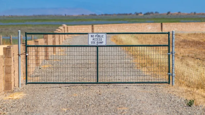
The road had been public for three miles. Then it wasn’t. A cattle gate, a chain, and a sign with a phone number and no explanation. The app on my phone still showed the little green polygon of national forest stretching ahead, but the fence had a different opinion. That’s the moment the map stops being a map and becomes a conversation—and not always a friendly one.
Public land in the United States is rarely a clean block. It’s a patchwork, and the seams don’t always show up on the screen in your hand. If you spend enough time hunting forest roads and trailheads, you’ll eventually meet the checkerboard: alternating square miles of public and private land, a legacy of nineteenth-century railroad grants. You’ll meet state trust parcels, which are often leased for grazing or hunting and are not automatically open to you. You’ll meet private inholdings tucked inside national forests, and tribal boundaries where access requires permission, not a GPS track. None of that makes the app wrong, exactly. It makes the ground more complicated than the pixels.
Why the Pin Lies (Even When the App Is Right)
Most land-access apps are doing something impressive: layering parcel data, agency boundaries, and topographic context into one view. But parcel data is only as good as its source, and sources vary wildly from county to county. A green pin can mean “public land” in the broad sense, while a smaller private parcel sits inside it like a splinter. A road can be public where it crosses one section and private where it crosses the next. State trust land can look like public land on a state map and still be closed to recreation. Tribal land can be shown as a boundary but not as a rule set.
The result is a familiar scene: someone parks at a gate that the app says is legal, and the person on the other side of that gate sees a trespasser. No one is lying. The map is just doing what maps do—flattening a messy landscape into a shape that fits on a screen.
The Three Maps You Actually Need
Start with the managing agency’s own map. For national forest, that means the U.S. Forest Service’s motor vehicle use map or district map. For BLM, the agency’s surface management map. These aren’t always pretty, but they’re built from the agency’s own records and they tend to show inholdings and access rules more honestly than a third-party overlay.
Next, pull the county GIS parcel viewer. This is the ground truth for who owns what, at least on paper. You’re looking for the parcel number, the owner name, and the exact boundary lines. If the road crosses a parcel marked private, you’ve found your conversation starter. If the land is state trust, look for the state land office’s access rules—many states allow recreation only with a lease or permit.
Finally, use satellite imagery. Not to navigate, but to read the fence line. Look for gates, cattle guards, signs, and the places where a road narrows or a fence cuts across it. Imagery can be months or years old, but it often shows the physical truth that the parcel layer misses.
A Step-by-Step Cross-Check
- Start with the agency map and note the road number, the district, and the nearest landmark. Write it down. Screenshots help.
- Open the county GIS viewer and search for the parcel where you plan to park or step off. If the property line runs down the middle of the road, that’s a red flag.
- Check the state land office if the parcel is state trust land. Look for recreation access rules, lease maps, or a phone number.
- Call the district office. Ask a specific question: “Is the gate at the end of Forest Road 123 open to public motorized access, and does the road cross any private inholdings?” You’ll get a better answer than “Can I go there?”
- Pack the paperwork—or at least the screenshots. If a landowner or ranch manager stops you, a calm “I checked with the district and the county parcel map” goes a lot further than a green dot on your phone.
Red Flags at the Gate
Some signs are obvious: “No Trespassing,” “Private Property,” “State Trust Land—Access Prohibited.” Others are quieter. A locked gate with no agency lock and no agency sign. A cattle guard with a “no motorized vehicles” placard that doesn’t match the app’s road layer. Purple paint on fence posts—in many states, that’s a legal no-trespassing mark. A fence line that cuts across a road the app shows as public. A gate that looks brand new and isn’t on the agency map. A road that dead-ends at a ranch entrance with fresh tire tracks and no turnaround.
None of these is proof of anything by itself. Together, they’re a signal to stop and check before you commit.
The Respectful Exit
If the gate says no and the map says yes, the gate wins. That’s not a legal opinion—it’s a practical one. You can call the district office from the truck, check the county parcel on your phone, and look for an alternate route. What you shouldn’t do is cut a lock, climb a fence, or argue with someone who lives there. The wild places we’re all looking for get a little smaller every time an access dispute turns into a confrontation.
A reroute costs you an hour. A trespass charge costs you a lot more, and it makes the next person’s access argument harder. The best days out are the ones where you come home with a story about the long way around, not a story about the sheriff.